map
Details
Description
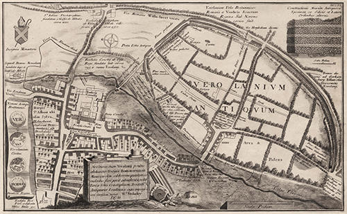
Engraving, 488 x 298 mm (plate size). Drawn by William Stukely.
Plan of the site of the Roman city of Verulamium, also including Kingsbury, Fishpool Street, Romeland, St Albans Abbey, Sopwell House, the hospital for lepers at St Julian's, and the churches of St Peter, St Michael and St Stephen. On the left are illustrations of the obverse and reverse sides of two Iron Age coins.
Plan of the site of the Roman city of Verulamium, also including Kingsbury, Fishpool Street, Romeland, St Albans Abbey, Sopwell House, the hospital for lepers at St Julian's, and the churches of St Peter, St Michael and St Stephen. On the left are illustrations of the obverse and reverse sides of two Iron Age coins.
Name/Title
William Stukely - Plan of Verulamium, 1721.
Media/Materials
Accession No
2008.5511
Comments
Be the first to comment.